
WATER EVERYWHERE (from left): Seepage of seawater into coastal marshes is believed to cause ghost forests like these on Assateague Island, Virginia. “Nuisance flooding” inundated the historic City Dock in downtown Annapolis, Maryland, several times this spring. NASA has had to invest tens of millions of dollars into seawalls and replenished beaches to protect launch pads and other infrastructure at its Wallops Flight Facility in Virginia. REUTERS/Kevin Lamarque; Mary F. Calvert; Kevin Lamarque
WALLOPS ISLAND, VIRGINIA, HOME TO NASA'S FLIGHT FACILITY IS LOSING GROUND TO THE SEA.
Its billion-dollar space launch complex occupies a barrier island that's drowning under the impact of worsening storms and flooding.
NASA's response?
Rather than move out of harm’s way, officials have added more than $100 million in new structures over the past five years and spent $43 million more to fortify the shoreline with sand.
Nearly a third of that new sand has since been washed away.
Across the narrow inlet from the NASA site, the beach at Chincoteague has disappeared at an alarming rate of 10 to 22 feet per year.
All along the ragged shore of Chesapeake Bay and the Atlantic coast of the Delmarva Peninsula, north into New England and south into Florida, all along the Gulf Coast and parts of the West Coast, people, businesses and governments are confronting rising seas not as a future possibility. For them, the ocean’s rise is a troubling everyday reality NOW.
All along the ragged shore of Chesapeake Bay and the Atlantic coast of the Delmarva Peninsula, north into New England and south into Florida, all along the Gulf Coast and parts of the West Coast, people, businesses and governments are confronting rising seas not as a future possibility. For them, the ocean’s rise is a troubling everyday reality NOW.
Beyond the cities, seawater and tidal marsh have consumed farmland and several once-inhabited islands.
Saxis, a Chesapeake Bay town, is also rapidly losing ground to the water. Some nearby villages have disappeared altogether.
“You’ve got to deal with the fact that it’s happening – and what are you going to do with those of us on the edge?" said Grayson Chesser, a decoy carver whose ancestors arrived in the Chesapeake Bay area four centuries ago.
“You’ve got to deal with the fact that it’s happening – and what are you going to do with those of us on the edge?" said Grayson Chesser, a decoy carver whose ancestors arrived in the Chesapeake Bay area four centuries ago.
It’s a question the U.S. government is dodging.
[NOTE: I WANTED TO PAUSE HERE AND SAY THAT I DON'T PERSONALLY CARE WHAT IS CAUSING THIS, NOR WHAT YOU WISH TO CALL IT. WHETHER THIS IS FROM CARBON EMISSIONS OR THE SEX PRACTICES OF SQUIDS, IT DOESN'T MATTER.
IT IS HAPPENING.
ONLY THE SELF-BLINDED WON'T SEE IT HAPPENING BY SIMPLY GOING TO EITHER COAST OR THE GULF AND LOOKING.
ALL YOU HAVE TO DO IS LOOK!
ALL YOU HAVE TO DO IS LOOK!
TWO OF MY MOST FAVORITE PLACES ON EARTH ARE GETTING HARD HIT BY THIS...THE COASTAL AREA FROM KEY WEST TO JUPITER INLET IN FLORIDA, AND GRAND BAYOU TO NEW ORLEANS IN LOUISIANA.
OVER A DOZEN OF MY FRIENDS/RELATIVES ARE LOSING GROUND TO THIS.
VERY BLUNTLY, SCREW WHAT'S CAUSING IT!
IT IS HAPPENING!
IF IT WAS HAPPENING TO ANY OF US, WOULD WE WANT HELP TO SAVE WHAT'S OURS?
WOULD IT MAKE A SOLITARY DAMN THEN IF IT WAS CLIMATE CHANGE OR WHALE URINE?
VERY BLUNTLY, SCREW WHAT'S CAUSING IT!
IT IS HAPPENING!
IF IT WAS HAPPENING TO ANY OF US, WOULD WE WANT HELP TO SAVE WHAT'S OURS?
WOULD IT MAKE A SOLITARY DAMN THEN IF IT WAS CLIMATE CHANGE OR WHALE URINE?
I WISH OUR ELECTED IDIOTS IN WASHINGTON WOULD JUST CLOSE DOWN THE BIG DOMED BROTHEL FOR A FEW DAYS AND SIMPLY GO LOOK, NO HANDS OVER THEIR EYES!]
TOO WIDESPREAD TO KEEP IGNORING
{REUTERS, CONTD)
More than 300 counties claim a piece of more than 86,000 miles (138,000 km) of tidal coastline in the United States, yet no clear national policy determines which locations receive help to protect their shorelines.
That has left communities fighting for attention and resources, lest they be abandoned to the sea, as is playing out in Chincoteague.
In many places, including much of the U.S. Eastern Seaboard, an additional factor makes the problem worse: The land is sinking.
This process, known as subsidence, is due in part to inexorable geological shifts. But another major cause is the extraction of water from underground reservoirs for industrial and public water supplies.
As aquifers are drained, the land above them drops, a process that can be slowed by reducing withdrawals."
[HERE, I DIFFER WITH REUTER'S AND OTHERS' TAKE ON THE AQUIFERS SITUATION.
WE HAVE A GROWING POPULATION TO FEED , WHICH MEANS BIGGER CROPS WILL NEED MORE WATER, AND ALL THOSE PEOPLE HAVE TO HAVE WATER TO LIVE.
SURE, WE CAN CONSERVE SOME, AND SHOULD WHERE WE CAN, BUT WE HAVE TO FACE THE FACT THAT EACH YEAR SEES AMERICA WITH MORE PEOPLE WHO WILL NEED MORE WATER FOR THE BASICS.
WHAT IS THE REALISTIC SOLUTION TO THAT?}
"Reuters spent months reporting from affected communities to show that, while government at all levels remains largely unable or unwilling to address the issue, coastal flooding on much of the densely populated Eastern Seaboard has surged in recent years as sea levels HAVE risen.
These findings, first reported July 10, are NOT derived from computer simulations like those used to model future climate patterns, which have been attacked as unreliable by skeptics of climate change research.
Reuter's analysis is built on a time-tested measuring technology – tide gauges – that has been used for more than a century to help guide seafarers into port.
Reuters gathered more than 25 million hourly readings from National Oceanic and Atmospheric Administration tide gauges at nearly 70 sites on the Atlantic, Gulf and Pacific coasts and compared them to flood thresholds documented by the National Weather Service.
The analysis was then narrowed to include only the 25 gauges with data spanning at least five decades (50 YEARS).
It showed that during that period, the average number of days a year that tidal waters reached or exceeded flood thresholds increased at all but two sites and tripled at more than half of the locations.
Since 2001, water has reached flood levels an average of 20 days or more a year in Annapolis, Maryland; Wilmington, North Carolina; Washington, D.C.; Atlantic City, New Jersey; Sandy Hook, New Jersey; and Charleston, South Carolina. Before 1971, NONE of these locations averaged more than five days a year. Annapolis had the highest average number of days a year above flood threshold since 2001, at 34.
On the Delmarva Peninsula, the annual average tripled to 18 days at the Lewes, Delaware, tide gauge.
On the Delmarva Peninsula, the annual average tripled to 18 days at the Lewes, Delaware, tide gauge.
As flooding increases in both height and frequency, it exacts a toll in closed businesses, repeated repairs, and investment in protection.
In effect, higher seas make the same level of storm and even the same high tides more damaging than they used to be.
[A YEAR AGO, IN "AMERICAN TOWNS DESTROYED BY RISING SEAS" WE SAW PHOTOGRAPHIC EVIDENCE OF THIS.
1,429 US Towns Could Be Destroyed By Rising Sea Levels
That will push more than 50% of the population out of 381 LARGE municipalities, resulting in 4,187,262 people losing their hometowns.
I WAS THERE, HOLDING MY BREATH, AS THEY MOVED THE CAPE HATTERAS LIGHTHOUSE OUT OF HARM'S WAY. THEY WILL HAVE TO MOVE IT AGAIN.
YES, IT IS WORSE IN COASTAL AREAS NOW WHEN STORMS BLOW IN, WHEN HIGH TIDES COME, WHEN IT RAINS FOR DAYS ON END.
GO BACK TO THAT ARTICLE, SEE THE EVIDENCE.
PRETEND THOSE ARE THE HOMES OF YOUR LOVED ONES, OR YOUR HOMES, THEN, MAYBE, CALL YOUR ELECTEDS?]
PRETEND THOSE ARE THE HOMES OF YOUR LOVED ONES, OR YOUR HOMES, THEN, MAYBE, CALL YOUR ELECTEDS?]
When Tropical Storm Nicole struck Maryland in 2010, it was no stronger than storms in 1928 and 1951 that were “non-events,” said the study’s author, David Kriebel, a Naval Academy ocean and coastal engineer. Nicole, by contrast, swamped downtown Annapolis and the Naval Academy. “It’s partly due to ground subsidence,” Kriebel said.
Coastal flooding has already shut down Norfolk’s $318 million light rail system several times since it opened in 2011. Mayor Paul Fraim said he needs $1 billion for flood gates, higher roads and better drains to protect the city’s heavily developed shoreline.
The Potomac River turns into a tidal estuary just north of Washington DC as it flows toward Chesapeake Bay to the south. The average number of days a year above flood threshold has risen to 25 since 2001, up from five before 1971.
In 2010, the U.S. Army Corps of Engineers began a $4.1 million project to close gaps in the line of flood protection for Constitution Avenue and the Federal Triangle area – home of the departments of Justice and Commerce, the National Archives and the Internal Revenue Service. The corps expects to finish in late autumn a 380-foot-long, 9-foot-tall barrier across 17th Street near the Washington Monument.
It still needs to raise by up to 3.5 feet a massive earthen berm built in the 1930s on the north side of the Lincoln Memorial Reflecting Pool. But Congress – high and dry on Capitol Hill – hasn’t approved the $7.1 million needed to finish that and two smaller projects.
SMALL TOWNS (NOR INDIGENOUS TRIBES, BTW) CAN'T RAISE FUNDS FOR SEA WALLS
“It’s becoming more and more competitive for federal funds in terms of protecting communities,” said Curtis Smith, a planner with the Accomack-Northampton Planning District. So Saxis is “competing with Miami and New York and Virginia Beach.”
Virginia Beach, with a population of 438,000, has been the recipient of a federally funded seawall and two major sand projects totaling more than $150 million since 1996.
Some Saxis residents have raised their houses to reduce the risk of flood damage. But that’s only a partial solution if the roads that connect them to grocery stores, hospitals and schools become impassable, Smith said.
“I wish I could say I thought Saxis would be saved, but there’s no way. It costs so much money,” Chesser said. “And even if you spend the money, I don’t’ think you can do it. I mean you just can’t beat the ocean. You’re going to lose every time.”
HE'S RIGHT, BUT WE CAN BUY TIME FOR MANY SUCH PLACES.
PEOPLE FACING THIS, THOUGH IT BEGAN YEARS AGO, STILL NEED TIME TO TRY TO SAVE WHAT CAN BE SAVED, OR FIND ANOTHER HOME.
IN MANY AREAS,THE "PREDICTED" RISE IN SEA LEVEL WAS FAR TOO LOW...THE SEA HAS RISEN FASTER THAN EXPECTED.
THE DENIERS, THE CONGRESSMEN WHO TURN BLUE AND SHUDDER AT THE VERY MENTION OF GLOBAL WARMING OR CLIMATE CHANGE DON'T WANT TO ALLOCATE FEDERAL FUNDS TO HELP THOSE WHO NEED HELP MOST.
IN MANY AREAS,THE "PREDICTED" RISE IN SEA LEVEL WAS FAR TOO LOW...THE SEA HAS RISEN FASTER THAN EXPECTED.
THE DENIERS, THE CONGRESSMEN WHO TURN BLUE AND SHUDDER AT THE VERY MENTION OF GLOBAL WARMING OR CLIMATE CHANGE DON'T WANT TO ALLOCATE FEDERAL FUNDS TO HELP THOSE WHO NEED HELP MOST.
THEY DON'T EVEN WANT TO GRANT A DOLLAR FOR THE MEASURES BEING TAKEN FOR THE DC AREA.
BUT LOOK AT THE PORK BARREL SPENDING REPORTS AND YOU'LL SEE WHAT THEY WILL SPEND MONEY ON!
MILLIONS AND MILLIONS IN PORK FOR THEIR STATES SO THAT THEIR CONSTITUENTS JUST MIGHT CAST YET ANOTHER VOTE FOR THEM.
MILLIONS AND MILLIONS IN PORK FOR THEIR STATES SO THAT THEIR CONSTITUENTS JUST MIGHT CAST YET ANOTHER VOTE FOR THEM.
IN FACT, LET'S LOOK AT ONE POLITICIAN WHO WANTED TO ENJOY A
$3 MILLION VACATION HOME ON AN ERODING FLORIDA GULF COAST BEACH.
IN HIS 2008 CAMPAIGN FOR PRESIDENT, EX-GOVERNOR MIKE HUCKABEE SAID :
$3 MILLION VACATION HOME ON AN ERODING FLORIDA GULF COAST BEACH.
IN HIS 2008 CAMPAIGN FOR PRESIDENT, EX-GOVERNOR MIKE HUCKABEE SAID :
"One thing that all of us have a responsibility to do is recognize that climate change is here, it's real," he said then. "That what we have to do is quit pointing fingers as to who's at fault and recognize that it's all our fault and it's all our responsibility to fix it."
TODAY, HE SAYS HE DOESN'T BELIEVE IN CLIMATE CHANGE ANYMORE.
A SPECIAL NOTE HERE TO ALL REGARDING THE TERM "CLIMATE CHANGE".... THE CLIMATE CHANGES DAILY, HOURLY, EVERY MINUTE OF EVERY DAY.
WHEREVER THERE IS CLIMATE, THAT CLIMATE CHANGES ALL THE TIME.
WHEREVER THERE IS CLIMATE, THAT CLIMATE CHANGES ALL THE TIME.
GOT IT?
INFORM A CONGRESSMAN?
INFORM A CONGRESSMAN?
BACK TO HUCKABEE, AND HYPOCRISY...
SANTA ROSA BEACH, Florida – Mike Huckabee bought a beachfront lot here in 2009, a year after his failed bid for the Republican presidential nomination. A longtime friend and political ally of the former Arkansas governor bought the lot next door. They planned to build $3 million vacation villas side-by-side, each with a pool and sweeping views of Walton County’s renowned sugary sand beaches and the azure waters of the Gulf of Mexico.
The only hitch was that their lots lay on a severely eroding beach. Under state regulations, they couldn’t build on the seaward side of the sand dune nearest to the surf. And after seven hurricanes in six years, the surviving “frontal dune” sat too close to the street to allow space behind it for the friends’ 11,000-square-foot (1,020-square-meter) compounds.
The structural engineer they had hired knew what to do. He dumped truckloads of sand farther out on the beach, shaped it into a mound, and declared the man-made hump to be the new frontal dune. When staff at the Florida Department of Environmental Protection (DEP) still balked at issuing the necessary permits, the engineer asked Michael Sole, head of the agency at the time, to intercede.
“I met with Secretary Sole on Friday …” the contractor wrote to DEP staff in a March 8, 2010, email, a copy of which was reviewed by Reuters. “I believe we’ve reached a consensus decision on the location of both these projects.”
The decision: Huckabee and his friend would nudge their home sites back 5 feet (1.5 meters). The permits were approved. Construction wrapped up in 2011.
In a written response to Reuters, Huckabee complained about “the slow-walking of the permits,” but said he was pleased with the outcome. “We enjoy the home and are blessed to be able to open it to our friends and family, which we do often.”
The ease with which Huckabee and his neighbors have been able to work around some of the most restrictive beach development laws in the country is indicative of a problem that only worsens as rising seas gnaw at U.S. shores: Americans are flocking to the water’s edge, as they have for decades, even as the risks to life and property mount. And government is providing powerful inducements for them to do so.
Between 1990 – when warnings were already being sounded on rising sea levels – and 2010, the United States added about 2.2 million new housing units to Census areas, known as block groups, with boundaries near the shore, a Reuters analysis found. The analysis did not include Louisiana, Hawaii or Alaska."
SO, WHILE MY FRIENDS ALONG THE ATLANTIC AND PACIFIC AND A FEW IN-LAWS WHO LIVE ALONG THE GULF COAST LOST PROPERTY, AND THOSE INDIGENOUS PEOPLE OF SOUTH LOUISIANA COULD NOT GET HELP PRIOR TO HURRICANE KATRINA OR TODAY TO PREVENT THE SEA FROM WASHING AWAY THEIR CEMETERIES, THE COFFINS OF THEIR DEAD, HUCKABEE AND HIS PAL WERE MANIPULATING THE SYSTEM TO BUILD VACATION HOMES WHERE NONE SHOULD HAVE BEEN BUILT?
HUCKABEE WAS GETTING HELP TO DO A FOOLISH THING WHILE OTHERS CAN'T SAVE THEIR CEMETERIES?
DO YOU BEGIN TO SEE A MAJOR PROBLEM HERE IN AMERICA?
IF THE PRESIDENTIAL RETREAT ON MARTHA'S VINEYARD WAS IN DANGER OF RISING WATERS FROM THE ATLANTIC, YOU CAN BET THE FARM THAT WOULD BE QUICKLY ATTENDED TO.
FOR TINY VILLAGES LIKE SAXIS, FOR INDIGENOUS COMMUNITIES LIKE GRAND BAYOU IN LOUISIANA OR ALASKAN NATIVE COMMUNITIES, NO FEDERAL AID EVER COMES, NO ONE LISTENS, NO ONE ASKS ANY FAVORS OF GOVERNMENT OFFICIALS ON BEHALF OF ANY OF THOSE.
CONGRESSMEN WILL FIND A WAY TO GET A COUPLE MILLION FOR THEIR FAVORITE RUM SUPPLIER IN PUERTO RICO TO EXPAND HIS BUSINESS, A FEW MILLION HERE, A FEW MILLION THERE, BUT NOT ONE MILLION TO SAVE A PLACE LIKE SAXIS...OR GRAND BAYOU...
WHEN SEAWATER SEEPS INTO COMMUNITIES, SEWERS FAIL, RAW SEWAGE FLOWS OUT INTO STREETS.
WATER SUPPLIES BECOME CONTAMINATED AND THE SALTWATER RENDERS THEM NON-POTABLE.
FARMING BECOMES IMPOSSIBLE AS SALINE LEVELS RISE IN THE SOIL.
MOST TREES DIE.
ANIMALS, WILDLIFE, HAVE TO LEAVE THE AREA.
AREAS NEARBY DEVALUE IN PROPERTY.
BUSINESSES CLOSE.
PEOPLE LOSE HOMES.
OVER 1400 COASTAL COMMUNITIES ARE GOING TO DISAPPEAR OR WILL HAVE TO BE ABANDONED TO THE RISING SEAS AND OVER HALF OF CONGRESS REFUSE TO ADMIT IT'S HAPPENING.
THEY WON'T GET OUT OF BED WITH WALL STREET DONORS LONG ENOUGH TO GO SEE FOR THEMSELVES, NOR WILL THOSE WHO BELIEVE WHAT THOSE LIARS TELL THEM.
LET THEM ALL SIMPLY GO LOOK...

Louisiana cemetery, after Hurricane Katrina
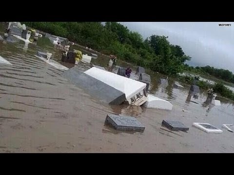
A nearby Louisiana cemetery, 2014...some things don't change.
An average of 17 square miles of the state are lost to the sea each year, and hurricanes speed up the disappearance.

An Inuit Village losing its battle with the sea.
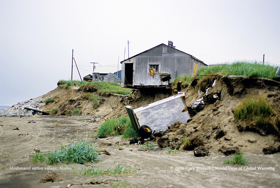
Shishmaref, Alaska...GOING, GOING...ALMOST GONE

Ocean City, Maryland, on the edge in rising seas

ST. AUGUSTINE, FLORIDA...LOSING IT

ON THE LEFT, AFTER HURRICANE IKE, THE EXACT PROPERTY HUCKABEE BOUGHT NEAR SANTA ROSA, FL.
BELOW THIS, THE SAME PROPERTY TODAY WITH HUCKABEE'S NEW $3 MILLION VACATION HOME.
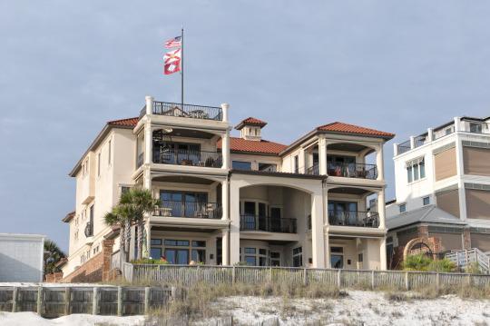
WILL THAT CREATED DUNE SAVE IT?
NO...BUT IS HUCKABEE DOING ANYTHING ABOUT GETTING HELP FOR OTHER COASTAL RESIDENTS?
OBVIOUSLY NOT....HE DENIES IT'S HAPPENING THIS CAMPAIGN.
NO...BUT IS HUCKABEE DOING ANYTHING ABOUT GETTING HELP FOR OTHER COASTAL RESIDENTS?
OBVIOUSLY NOT....HE DENIES IT'S HAPPENING THIS CAMPAIGN.
No comments:
Post a Comment